
Features
Drainage Management Systems
Software accompanies Ontario’s agricultural erosion control course
Recognizing the risks of erosion in one-sixth of farms in Ontario.
November 7, 2012 By Kevin McKague*
 A good percentage of Ontario’s cropland remains at risk of severe water erosion unless landowner attention is paid to its control. Agriculture and Agri-Food Canada (AAFC) has estimated that 16 percent of the cultivated land in Ontario is at high to severe risk of inherent (bare soil) water erosion.
Agriculture and Agri-Food Canada (AAFC) has estimated that 16 percent of the cultivated land in Ontario is at high to severe risk of inherent (bare soil) water erosion. As a result, landowners, especially those intensively cropping their land, need to manage it in a way that can reduce this risk of valuable soil loss. Producers rely heavily on agronomic forms of erosion control such as extending crop rotations to include perennial crops and using cover crops, conservation tillage, residue management and cross-slope cultivation to keep soil loss in check. Despite using one or more of these practices, there are often areas of the field, particularly where water concentrates and flows downslope, that need extra attention.
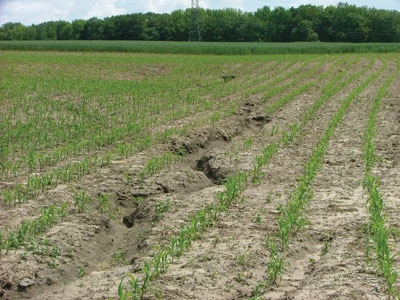
Otherwise large rills and even gullies can form (see photo below). Agricultural erosion control structures such as grassed waterways and diversions, grade control structures, and water and sediment control basins (WASCoBs), are often the best solution in these situations.
Ontario Ministry of Agriculture, Food and Rural Affairs (OMAFRA) has offered contractor training in the design of the more common agricultural erosion control practices since 1987. Designs developed using the techniques taught in the course are recognized as meeting the minimum design standards needed to qualify an erosion control project for cost share funds through Ontario’s Environmental Farm Plan (EFP) program. The latest edition of the Agricultural Erosion Control Structures Design Manual (Publication 832) can be ordered online.
During the winter of 2010-2011, OMAFRA is offering an updated five-day training course that gives participants familiarity with the information provided in Publication 832. Previous courses covering the manual typically lasted up to two weeks. This course, however, will focus primarily on design aspects of the erosion control structures covered. Background materials will also be provided for participants to review prior to attending the course. An exam will be offered to those wishing to receive accreditation as an erosion control contractor.
An additional benefit to completing the course will be the opportunity to become familiar with the new AgErosion software that has been developed to simplify the design calculation steps described in Publication 832. Like the course, the software guides the user through the steps needed to complete design calculations for the following:
- Determination of peak flows from small agricultural/rural watersheds;
- Grassed waterways;
- Rock chutes and spillways;
- Drop pipe inlets;
- Grade control structures, and
- WASCoBs.
The software is currently in “beta testing” stage. The first version’s release is anticipated to correspond with the next course offering (early in 2011). Those attending the course will get an opportunity to become familiar with the software. Those successfully completing the course will be given a copy for their use. Professional engineers, familiar with erosion control design, will be able to obtain a copy of the software when it becomes available, without completing the course, upon their request.
The AgErosion allows the user to organize and design a variety of erosion control projects for their clients. After entering a client’s address and the project location, the user will typically proceed to the “watershed characteristics” screen. Here, watershed area, watershed length and grade as well as the watershed information needed to determine a runoff curve number is entered to quickly generate a table of peak flows, storm durations and runoff volumes (see Figure 1).
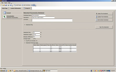
Figure 1
Information in this table can then be used to help in the design of a variety of structural measures at the point of concern in the field. The option exists to complete the work in either imperial or SI (metric) units.
The output will mimic the design information sheets that are provided in Publication 832. This can help make the preparation of design information needed to support a cost-share application quicker. Generic sketches of the planned project can also be printed with the design information sheets. Figure 2 shows a sample sketch prepared for a proposed single WASCoB project.
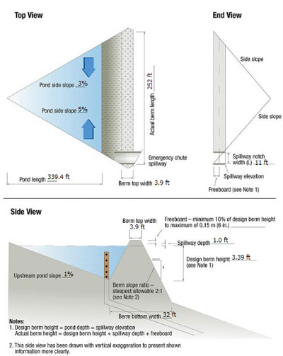
Figure 2
For more information
If you require more information on the erosion control course, Publication 832, or its associated software, contact OMAFRA’s agricultural contact centre. They will be able to answer any questions you may have or place you in touch with other specialists within Ontario’s Ministry of Agriculture, Food and Rural Affairs.
*Kevin McKague is a water quality engineer with the Ontario Ministry of Agriculture, Food and Rural Affairs.
Print this page