
Features
Drainage Management Systems
Choosing the perfect plot
Evaluating site suitability for controlled drainage and saturated buffers.
May 2, 2018 By Ben Reinhart Dan Jaynes Mark Tomer and David James
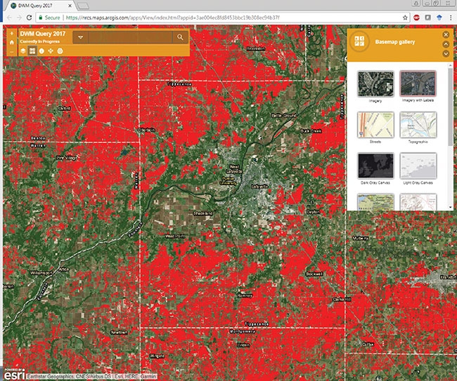 Online viewer showing potentially suitable cropland soils for implementing the practice of controlled drainage. Location
Location, location, location. This old adage used in real estate hints at the fact that not all properties are equal and the characteristics that make up a place will affect the value of that property.
This same relationship applies to evaluating the suitability of sites for practices such as controlled drainage and saturated buffers. Two new tools are available that drainage contractors can use in evaluating the suitability of potential sites for these practices.
Controlled drainage
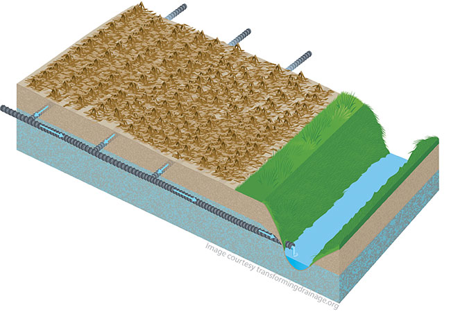
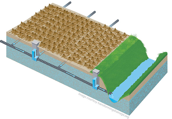
Controlled drainage is the practice of using water control structures in subsurface tile drains to manage the depth of the drainage system outlet. For example, water control structures that are set at the depth of the tile drain are able to drain freely, similar to an uncontrolled tile drainage system. Water control structures set at shallower depths (i.e. closer to the soil surface) retain tile drain water in the soil profile and cause the water table rise. The overall result leads to reduced total tile drain flow volumes, which can offer improvements in water quality and water availability to crops in tile-drained agriculture.
The primary factors in determining suitable agricultural sites are topography and soil type. The more variability that we have in both, the more difficult (and costly) it becomes to not only implement but also manage controlled drainage systems. The first estimates of cropland suitable for the practice of controlled drainage, developed by NRCS soil scientists in 2012, provided valuable information on the regional potential for the practice. In working in collaboration with researchers from the Transforming Drainage project, NRCS soil scientists have developed new estimates using more recent soils and cropland data and results are now viewable in an online GIS viewer. This online tool allows drainage contractors to take advantage this spatial analysis and to help evaluate the potential for implementing controlled drainage in Midwestern tile-drained agriculture. The tool is accessible at www.transformingdrainage.org/tools/cd-suitability and identifies land in the upper-Midwestern United States that has a high probability of being suitable for the practice of controlled drainage. These estimates are based on the following criteria:
- Land use is determined to be cropland (source: 2015 USDA-National Agricultural Statistics Service Cropland Data Layer)
- Field slope is less than or equal to one percent (Source: 2017 USDA-NRCS Gridded Soil Survey Geographic [SSURGO] Database)
- Soil types that naturally have a water table within 18 inches of the surface during the growing season, and thus are likely tile drained (Source: 2017 USDA-NRCS Gridded Soil Survey Geographic (SSURGO) Database)
- Mapped soil units that are at least 15 acres or larger in size, and thus are considered the most economically cost-effective to control tile drainage with the fewest number of water control structures (Source: 2017 USDA-NRCS Gridded Soil Survey Geographic [SSURGO] Database)
It is important to note that the online viewer does not take into account property or field boundaries. So, as in any project, the project planning should further evaluate any potential impacts on neighboring landowners and land uses. In some cases, areas not identified in the map may actually be suitable for controlled drainage depending on the site-specific topography, drainage system layout, and other factors. This online viewer does not replace the need for field verification by a drainage contractor or engineer. However, this resource provides an easy to use, open-access tool to evaluate quickly potential locations for implementing controlled drainage.
Online viewer showing potentially suitable cropland soils for implementing the practice of controlled drainage.
Saturated buffers
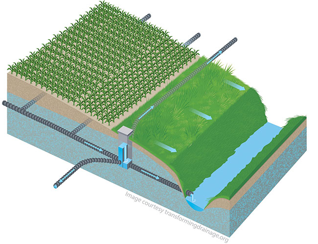
Typically, tile drainage water is discharged to either a county main or to a drainage ditch or stream. When the tile outlets to a ditch or stream, the tile flow bypasses the near-stream (or riparian) soils. Riparian soils are well suited to remove nutrients, especially nitrates, from water. The saturated buffer is a new practice that discharges a portion of the tile drainage water into riparian soils, which reduces nitrate concentrations from drainage water before it enters the stream or ditch. Basically, a saturated buffer consists of a water control structure that is installed into the tile line just upstream of the outlet, within a streamside buffer. The water control structure is used to raise the water height at the outlet and divert some of the tile flow through a perforated pipe installed roughly parallel to the stream and as close to the surface as possible. Some of the tile water (and nitrate) seeps into the buffer and flows as shallow groundwater to the stream. Nitrate is removed within the buffer by natural biological activity using carbon stored in the soil and renewed by the growing perennial vegetation within the buffer.
Saturated buffers are fairly inexpensive and easy to install, but to function properly, specific soil and landscape factors need to be satisfied. The USDA Agricultural Research Service has developed a GIS-based toolbox, called the Agricultural Conservation Planning Framework (www.northcentralwater.org/acpf/), which includes a tool that identifies riparian locations that are well suited to the saturated buffer practice. The tool checks soil survey information to ensure the soils should have organic carbon concentrations sufficient to support nitrate removal, and that the soil hydrology will help keep the discharged tile water at shallow depth where that carbon is found. There are also two topographic criteria that must be satisfied, which are used to reduce the chances of unintended consequences from installing the practice. First, the new USDA-NRCS standard for this practice specifies that bank heights should be less than eight feet, so that the risk of bank collapse is minimized. Second, the slope of the riparian zone above the stream bank is also important. If the slopes are less than two percent, there is a risk that the practice may inundate some of the crop above the buffer. If the slopes are greater than eight percent, there is a risk that the tile water may seep out and flow over the soil surface, leading to erosion. Therefore, the tool checks that a substantial portion of the riparian zone is comprised of two to eight percent slopes. By default, a “substantial portion” is defined as 35 percent of the riparian zone, but a planner familiar with soils in the area is able to adjust that criteria to be either more or less restrictive. A preliminary statewide analysis for Iowa found more than 14,000 miles of streambanks that met all suitability criteria for saturated buffers (note: one mile of stream has two miles of stream bank).
The Transforming Drainage project
The Transforming Drainage project is an eight-state project of 15 leading agricultural engineers, soil scientists, agronomists, economists, social scientists, and database and GIS specialists with a common vision ¬ to transform the way we implement drainage across the agricultural landscape. Our team works to bring together people, data, and tools to learn from each other and explore new ways to increase water storage in tile-drained areas as a way forward in improving water quality and water availability in Midwestern agriculture. The network of drainage professionals, engineers, and farmers involved in the Transforming Drainage project continues to grow across the region. If you are interested in finding out more about the project, tools, and resources go to www.transformingdrainage.org and stay tuned for future tools from the project.
Ben Reinhart is the project manager for the Transforming Drainage project and staff in the Agricultural and Biological Engineering Department at Purdue University. You can contact him at 765-496-6331 or breinhar@purdue.edu.
Dan Jaynes and Mark Tomer are research soil scientists and David James is a geographic information specialist at the USDA National Laboratory for Agriculture and the Environment in Ames, IA.
Print this page