
News
Gulf of Mexico dead zone ‘above average’
August 5, 2015 By NOAA
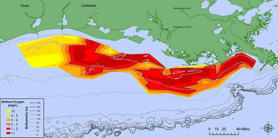 This map illustrates the distribution of bottom-water dissolved oxygen from July 28 to Aug. 3 Scientists report this year’s Gulf of Mexico dead zone — an area of low to no oxygen that can kill fish and marine life — is above average at 6
Aug. 5, 2015, Washington, DC — Scientists report this year’s Gulf of Mexico dead zone — an area of low to no oxygen that can kill fish and marine life — is above average at 6,474 square miles.
Dead zones, also called hypoxia areas, are caused by nutrient runoff from agricultural and other human activities in the watershed. They are highly affected by river discharge and nitrogen loads. These nutrients stimulate an overgrowth of algae that sinks, decomposes, and consumes the oxygen needed to support life in the Gulf.
This year’s dead zone is larger than the 5,052 square miles measured last year, indicating that nutrients from the Mississippi River watershed are continuing to affect coastal resources and habitats in the Gulf.
A suite of National Oceanic and Atmospheric Administration (NOAA) sponsored models forecasted a dead zone in the range of 4,633 to 5,985 square miles, based on May nitrogen loading data provided by the United States Geological Survey (USGS).
“An average area was expected because the Mississippi River discharge levels and associated nutrient data from May indicated an average delivery of nutrients during this critical month, which stimulates the fuel for the mid-summer dead zone,” said Nancy Rabalais, executive director of the Louisiana Universities Marine Consortium (LUMCON). Rabalais led the July 28 to Aug. 3 survey cruise.
“Since the models are based largely on the May nitrogen loads from the Mississippi River, the heavy rains that came in June with additional nitrogen and even higher river discharges in July are the possible explanations for the larger size,” Rabalais added.
The annual measurement mapping of the dead zone is funded by NOAA and the Environmental Protection Agency (EPA) to provide a critical scientific record of the trend of hypoxia in the Gulf. These findings are also the primary measure of progress used by the Hypoxia Task Force to determine whether efforts to reduce nutrient loading upstream in the Mississippi River Basin are yielding results.
The average size of the dead zone over the past five years has been about 5,500 square miles – nearly three times the 1,900 square mile goal set by the Hypoxia Task Force in 2001. The task force reaffirmed this target in 2008.
The largest previous Gulf of Mexico dead zone was recorded in 2002, when the zone encompassed 8,497 square miles.
The smallest dead zone on record measured 15 square miles in 1988.
Print this page