
Features
Contractor at Work
Digging into drones
Contractors can still benefit from the technology without buying a drone for themselves
October 30, 2018 By Stephanie Gordon
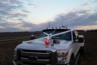
 One of the benefits of drones is being able to take on large scale projects, and not be limited by barriers on the ground. Photos courtesy of Corey Getz.
 Drones need no introduction. Stories about drones hover on technology websites and never seem to go out of style. But what value does this former “next big thing” bring to the drainage industry?
Scott Hiebert is the co-founder of Green Aero Tech, a drone mapping service serving Western Canada. His company offers a mapping service that primarily uses drones, or UAVs, to create an accurate elevation and visual model of a field. After showing what drones can do to his first customer, the customer responded with “that’s a pretty picture, but none of that matters until I’ve got my water under control.”
After showing what drones can do to his first customer, the customer responded with “that’s a pretty picture, but none of that matters until I’ve got my water under control.”
Drones can be used to help drainage contractors, but the priority is still installing good drainage. Over the past several years since drones have landed in the industry, the general verdict amongst contractors is drones aren’t worth the time, money, or the learning curve that’s required to use them. What’s more, it’s not feasible for each individual contractor to buy a drone to survey a field. Drones and drainage are remaining as two seperate industries, with drainage contractors who see the value in the data provided opting to contract out to drone companies to utilize their services.
“It’s economies of scale, we don’t know anybody that’s big enough to make it work,” Hiebert starts. “I’ve got three [drones] in the truck right now . . . and a typical crew will probably run $80,000 to $100,000 CAD [$62,000 to $78,000 USD] worth of equipment with them.” Green Aero Tech currently spreads that investment over four provinces across Canada and plans to expand into the United States too.
In the United States, Corey Getz and Quint Shambaugh are co-founders of DIGS Associates, where they use UAVs for topographic data collection on large scale watersheds and design engineer drainage water management systems. Both Getz and Shambaugh were drainage contractors designing and installing tile before moving on to create DIGS Associates. They’re aware of the barriers facing contractors to adopt this technology, but want to help contractors benefit off the technology to improve how drainage is done. “Corey and I, when we participated in the industry, we saw some things that we wanted to make better and that’s how we developed this business model,” Shambaugh says.
They’re aware of the barriers facing contractors to adopt this technology, but want to help contractors benefit off the technology to improve how drainage is done.
The costs of the drone hardware, software, accessories and all the knowledge it requires, is a cost absorbed by drone companies that offer up their services to contractors.
Pros and cons of using drones
It’s no surprise that a con associated with using drones is the cost involved – commercial-grade equipment can have high price points that are inaccessible to some. However, even in the past couple of years the accuracy and ability of UAV equipment has grown. Drones can cover more ground and produce more accurate data than a traditional in-field survey. They can fly over wet, rough ground and reach places other equipment, such as a side-by-side, cannot. Being in the air eliminates a lot of barriers faced on the ground.
“The fields can be muddy, they can have bales on them, the guy can be cultivating, it doesn’t have to be harrowed, as long as it’s harvested, or I can see 50 percent [of the ground], we’re going,” Hiebert says. As a farmer himself, Hiebert also mentions that drones help avoid biosecurity concerns because you don’t have to enter the field to gather the data. Green Aero Tech also gathers visual images, not just data points, but a bird’s eye view of the field so one can cross-reference the data if there’s irregularities. Hiebert explains one of the positives of photogrammetry (where measurements are made from photographs) is the accuracy, but one of the downsides is not being able to see through thick vegetation.
Flying means that you don’t have to follow a snake pattern, like most contractors do when driving a field. Shambaugh explains how the drones collect data in a grid pattern, so you can have every inch covered, and can determine with more accuracy where the low and high spots are. An average project for DIGS is close to 1,000 acres and they typically collect three layers of data.
Shambaugh explains how the drones collect data in a grid pattern, so you can have every inch covered, and can determine with more accuracy where the low and high spots are.
Drones do have their limits: they don’t work well with water, wind and vegetation. If there is too much water on a field, there will be reflectivity that will affect the data collected. If there’s too much wind, the drone won’t be able to stabilize itself at a certain elevation. Finally, vegetation, like trees or standing crops, give off false readings and prevent the drone from feeding back accurate data. The best times to fly are right after harvest up until there’s snow on the ground, and after the snow melts but before the crop is too high – which is still a larger window than on-the-ground surveys.
With this larger window, the scope of projects they’re able to tackle is also larger. “We look at things from a holistic scope, and so when we have a client that contacts us about 80 acres, we don’t just identify their 80 acres . . . we identify all the water that hits the watershed that could possibly affect the 80 acres,” Getz says. Looking at the bigger picture allows DIGS to look at larger-scale nutrient loss reduction strategies that can help an entire watershed and not just an individual landowner. Working within an entire watershed allows for opportunities for landowners to work together, share in mains, sub-mains, or lower their costs with cost-sharing.
Would these kinds of large-scale, long-term solutions be possible without drone technology? “Not even close,” Getz says. “There’s no way we would be able to be where we are at today to identify watersheds like we do, as quickly as we do . . . it allows us to get it done in one project rather than have several projects over the course of a decade or two.” With news stories fixating on water pollution, nutrient runoff and other environmental concerns, these holistic approaches made possible through drone technology could be a way forward for policy makers and contractors alike.
Drone setup usually takes up to 30 to 45 minutes.
How can contractors benefit from using drones?
Ryan Maltby is a drainage contractor working 20 miles south of Springfield, IL, installing field tile, excavating, and completing all other forms of dirt work. Maltby has worked with DIGS on several projects since the company started three years ago. The maps, data and drainage plan he receives from DIGS help Maltby with the legwork part of drainage so he can concentrate on putting tile in the ground.
“I don’t know if you can put a dollar amount on the amount of time it saves you,” Maltby says. Contractors do most of their work when the weather is nice, whereas drones can fly when it’s muddy or freezing temperatures. “You don’t really want to take the time to go drive a field and do a design when you could be spending your time more wisely actually getting the work done.” In addition, the drones don’t tear up the ground and preserve equipment that would’ve been driven through a chisel-plowed field in the middle of winter.
“You don’t really want to take the time to go drive a field and do a design when you could be spending your time more wisely actually getting the work done.”
Drones also help gather information after a big rain, without needing the land to dry, so that drainage contractors can better understand the damage. Reading after the rain paints a more accurate picture about how much water is actually held by the land. Maltby explains that when you’re in the air looking at a hole that is holding water, you’re able to better understand what gear you need. “You can upsize your tile to make sure you handle that amount of water, which is a big part of making a customer happy at the end of the day.”
DIGS has been compiling all the data the company has been collecting over the years of surveying watersheds. Currently, the information is shared with contractors who work with them on a project, but they continue to pursue other layers of data for their files to use for future projects. In addition to gathering data, DIGS creates drainage plans, but they’re always reviewed by the contractor they’ve partnered up with to execute the project. “We want them to have more information, we want them to be in the driver’s seat, we want them to make informed decisions,” Shambaugh says.
Drone information can be a lot to sift through. It’s only a pretty picture until you’re able to do something with it. “That’s exactly why we’re here,” Shambaugh says. “We ask a lot of our contractors: we ask them to be engineers, we ask them to be mechanics, we ask them to be accountants, we ask them to be salesmen . . . we’re here to help them determine the information.”
Green Aero Tech currently only offers drainage analysis without providing the final drainage plan, but Hiebert still sees value in working with contractors. In Hiebert’s own experience across Western Canada, their biggest hurdle is landowners not taking water management seriously. “That’s where these contractors have a lot of value, and that’s why we like working with them, because the data gets used,” Hiebert says.
The costs of the drone hardware, software, accessories and all the knowledge it requires, is a cost absorbed by drone companies that offer up their services to contractors.
Using drones to find old drainage pipes
Barry Allred, a USDA research agricultural engineer, and Greg Rouse, a GIS co-ordinator for Ross County Soil and Water Conservation District in Ohio are creating guidelines that will help people use drones to locate old drainage pipe. They started mapping tile lines as they were being put into the ground, giving the farmer X and Y co-ordinates showing the tile lines. But then turned their focus to the lines already in place, trying to find an efficient way to map old drainage tile to help farmers and contractors who are retrofitting and repairing tile.
One significant observation to date, according to Allred and Rouse, is that several days after a large rainfall event, the tile is easier to see. “The soil directly over the drain line will dry out first, be lighter in colour and reflect more light, and have a different temperature compared to the soil between the drain lines which is darker and might also be a different temperature,” Allred explains. So far, the project has seen a lot of success with thermal imagery to spot old pipe. Water has a very high specific heat capacity, so depending on the time of day, there will be temperature differences in the soil above the drain line versus the soil between the drain lines.
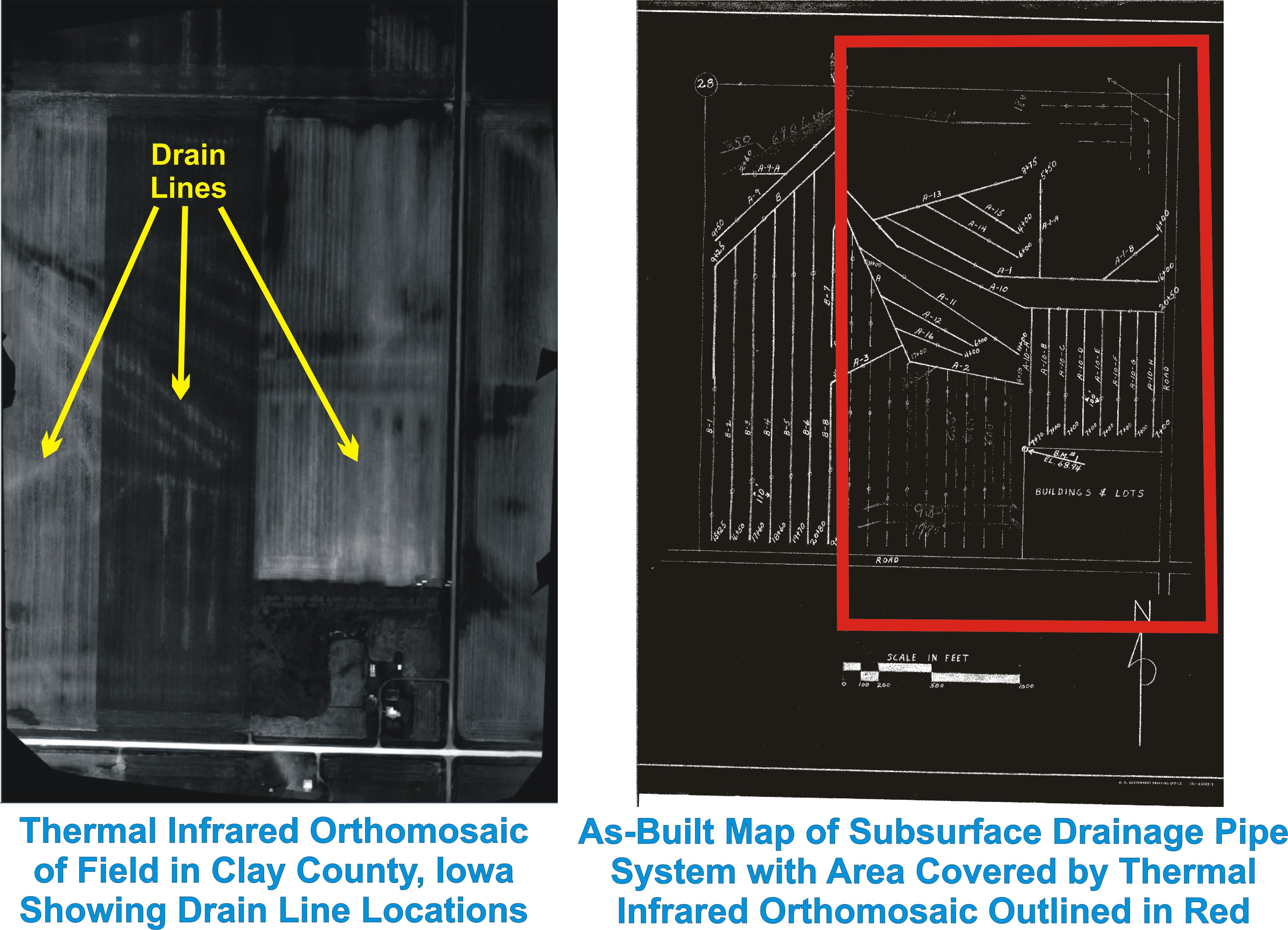
After a large rainfall event, drain lines are easier to spot using thermal infrared cameras attached to drones. Photo courtesy of Barry Allred and Greg Rouse, obtained in co-operation with Adam Batschelet, WinTec Arrowmaker Inc.
The research will determine guidelines for the optimal time to be out in the field to collect imagery that will produce maps of old drainage pipes. The researchers are looking at soil wetness conditions, crop residue, soil temperature, the size of a rainfall event and how long after a rainfall event will produce the best results. The project so far has collected data in Ross County, OH, elsewhere across the state of Ohio and in parts of the Midwest. No conclusions have been made yet, but Allred and Rouse hope to collect a majority of their data when there’s bare ground over the next couple of months and have some preliminary guidelines before planting starts again next year.
“There’s a huge amount of subsurface drainage that’s been installed throughout the Midwest, U.S. and Canada, where maps of the existing systems are not available, but the farmers or drainage contractors would certainly like to have those maps,” Allred says. “I would think that this concern would be a market for those that have drone imagery services.”
Final words
Are drones going to become more commonplace in drainage? Maybe not, but maybe more contractors will experiment with using the data and maps that this new technology can provide to better their own practices.
“The farmers use technology more and more every year, so therefore we have to use technology more and more every year,” Maltby notices. “You’re always going to find people who want to do it the old way and think that’s good enough, but I feel like to be a sustainable contractor nowadays you have to embrace as much technology as you can.”
“You’re always going to find people who want to do it the old way and think that’s good enough, but I feel like to be a sustainable contractor nowadays you have to embrace as much technology as you can.”
Scott Hiebert, of Green Aero Tech, agrees with contractors who don’t immediately see the value of drones. His company has invested a lot of time and effort testing various UAV equipment to see what works best. After many tries working with wrong equipment, he knows the difference between what a $10,000 drone can do and what a RTK (Real Time Kinetic) or PPK drone is capable of. Hiebert tells contractors that just because you had some drone work done and it wasn’t good, it doesn’t mean the technology isn’t there. “[When] done properly with the right equipment it works.”
At the end of the day good business decisions keep the customer in mind. As a farmer, farming 12,000-acres in Manitoba where there’s water issues, Hiebert takes his investment in drainage seriously. “Don’t go out there and use old or poor data, you don’t want to skimp on that.”
Print this page