
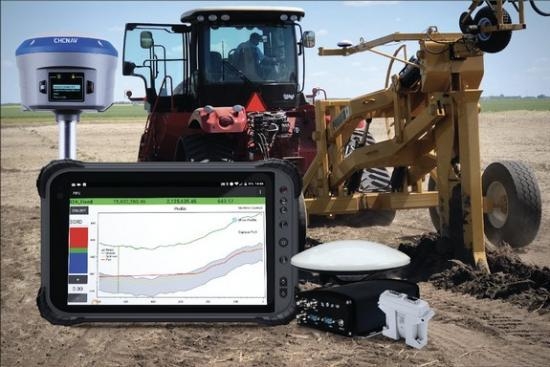
AMW Machine Control Solutions Inc. has announced the introduction of its new AMW PIPE and AMW DITCH machine control solutions focused primarily on the agricultural market. These products are suited for agricultural water management applications where automatic drainage-tile installation and land shaping for waterways is required. Each of these new machine control solutions is user-friendly and runs on an Android operating system and CHC Navigation GNSS hardware.
AMW PIPE is an automated tile plow control solution that adds GNSS based machine control to most tile plows, whether towed or fixed to the tractor. Utilizing a design file, AMW PIPE automatically controls tile plow depth and tile pipe slopes to minimize the installation depth of drainage tiling or utilities and to ensure rate-of-flow design objectives are met. AMW PIPE also records actual tile placement in real time, enabling as-built record keeping and facilitating future tile relocation. AMW PIPE uses Vertical Curve Technology (VCT) to design subsurface pathways that minimizes needed depth while achieving desired flow rates.
AMW DITCH is an automated ditcher and scraper control solution. This product is ideal for surface ditch construction utilizing a scraper, blade or ditching machine. It automatically controls the depth and slope of above ground drainage design. It can follow a design file done in AMW’s optional WATERCOURSE CAD design tool, or by driving the terrain utilizing a GNSS receiver from low to high ground or vice versa. Users can easily set depth and slope parameters and AMW DITCH will use GNSS RTK to accurately control the earth moving equipment. AMW DITCH will always minimize ditch depth and earth movement while achieving optimal surface water flow.
Both AMW PIPE and AMW DITCH also support topographical map creation by driving the terrain with a GNSS receiver installed to your vehicle and/or by layering a geo-referenced yield map, Google map, satellite image, aerial photo or other user-defined maps to identify water ponding areas and drainage strategies for drainage planning. Topo Map and other map overlays input into AMW WATECOURSE CAD design tool, will allow the user to design a complete water management plan for the entire area of concern.
Print this page